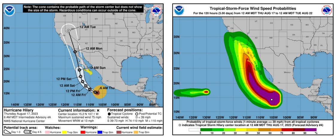
Hurricane Hilary is forecast to approach or track into southern California over the weekend and into early next, bringing widespread showers and thunderstorms and possibly stronger winds to Southern California. Forecasters warn that it’s still too soon to confirm when — or if — Hurricane Hilary might make landfall, and how strong the system could become.
- The location and intensity of precipitation and winds will be highly dependent on the track of Hurricane Hilary.
- Please monitor National Hurricane Center forecasts for additional real-time updates.
- Moderate to heavy precipitation is expected across portions of southern California, with flooding impacts possible
- River rises are also expected in southern California, especially in San Diego areas, beginning Saturday night
- The last time SoCal experienced this very rare phenomenon was over 80 years ago when a storm nicknamed El Cordonazo or The Lash of St. Francis — hit Long Beach in September 1939
What to Expect: Heavy Rains, Possible Flooding and Tropical Force Winds
- Rain starting early Saturday morning continuing through late Monday afternoon
- Sunday is the day of concern with a maximum 24 hour rainfall range expected to be between 2-5 inches
- Rainfall will be the greatest risk with possible heavy rain for a 12-24 hour period starting Sunday morning @0000
- Possible flooding could occur and is expected in burn scarred areas
- Tropical wind gusts (Peak 75 mph) and sustained wind flows (25-45mph)
What You Can Do:
- Be Prepared. Review CDC Resources on Preparing for a Hurricane or Tropical Storm ( Spanish)
- Stay abreast of the weather updates as they become available
- Prepare to work from home on Monday (if necessary)
- Monitor travel plans and assess whether you need to go out on Saturday/Sunday
- Stock up on supplies
- Avoid Flooded areas: do not drive in flooded areas
